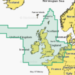
Navionics U.K. Platinum+ Ireland UK
Discover the ultimate in marine navigation with Navionics Platinum+ U.K. & Ireland, the premium chart that brings every detail of your boating environment to life. Covering the entire coastline of the United Kingdom and Ireland, this advanced chart is designed for sailors, anglers, and professional mariners who demand the highest level of accuracy and detail on the water.
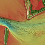
The Platinum+ range offers exceptional chart coverage that includes both inshore and offshore areas, giving you precise information for every route. High-definition bathymetric contours and depth shading reveal underwater structures and seabed variations, allowing for safer navigation and improved fishing accuracy. Whether you are exploring new coastlines or returning to familiar waters, the clarity and precision of these charts make every trip more enjoyable and secure.
Adding to its impressive functionality, Navionics Platinum+ includes satellite overlay imagery and dynamic 3D views. These features allow you to visualize your surroundings in remarkable detail, combining realistic land and sea perspectives with traditional chart data. The result is an intuitive, informative view that enhances your awareness of the marine environment.
Harbor and marina information is included in rich detail, providing port plans, anchorage points, tidal data, and available services. This makes it easier to plan your stops, manage fuel and supplies, and approach marinas with confidence. Every aspect of your voyage is supported by data designed to make navigation more efficient and stress-free.
With daily updates available through the Navionics Chart Installer and the ActiveCaptain® app (subscription required), you can always stay current with the latest chart information. Changes to coastlines, buoy positions, or depth data are reflected automatically, ensuring you are using the most up-to-date navigation information available.
Compatibility is another key advantage. The Navionics Platinum+ U.K. & Ireland chart works seamlessly with major chartplotter brands including Raymarine, Lowrance, Simrad, and B&G, allowing easy integration with your existing marine electronics.
Whether you are a leisure boater, sport fisherman, or experienced mariner, Navionics Platinum+ delivers the most advanced combination of coverage, detail, and reliability available today. With its blend of cutting-edge mapping technology, accurate hydrographic data, and visual enhancements, it provides a complete solution for anyone navigating U.K. and Irish waters.
Compatibility
Check Compatibility of Navionics content and features with your GPS chartplotter.